Exercise for Valentina Nisi's
Media Portrait of the Liberties
Description
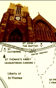
Media Portrait of the Liberties (MPL) presents a multimedia map of the Liberties area in Dublin. MPL was generated by local residents, who submitted stories, anecdotes, or images to an online database via a phone or gps device. Each submission relates to a particular area, intersection, building, or phenomena in the Liberties. The final product is not a cohesive, linear map. Instead, the MPL is a fragmented map that has different kinds of information and material, depending on the location that the visitor chooses.
Purpose
This exercise will expose students to alternative forms of cartography (see glossary)
made possible by new media.
Instructions/Notes
MPL is a Windows application.
To install MPL, click "Launch Project" and run the "grok-mpl-setup.exe" installer.
To run the application, click "Start Menu -> Programs -> Grok -> Media Portrait of the Liberties".
When the application starts, it will prompt you with a File Open dialog.
Navigate to "Program Files\GROK\Media Portrait of the Liberties" and select the "liberties" text file.
Click Open and the application will launch.
Media Portrait of the Liberties requires speakers or headphones.
Materials
The educator should prepare multiple maps, hung or displayed for discussion purposes. In addition, the educator should acquire a large map of the local area and smaller photocopies for the students.
Exercise
Warm-Up Activity (10 min):
Educator should facilitate a discussion about cartography, explaining the term and prompting students to consider other kinds of geographic visualization. Suggested questions could include:
- Which of these maps provides the most accurate presentation of the area?
- Which map would you find most useful?
- Who made this map?
- Do you think there are areas that are left out?
- What are the geographical or urban features that this map highlights?
- What are other ways that the city could be mapped? For instance, could it be mapped by the population of humans or birds?
Play (15 min):
Students should spend time playing MPL. The educator should contextualize MPL by explaining that it is site-specific and interactive, and that the content is documentation supplied by local residents.
Activity (25 min):
In groups, students should find an area on the map that they have a special memory of: school, home, a friend's house, a park, etc. The students should write or draw a story about the place on a small piece of paper. After presenting their contributions to the class, students will pin their papers onto a larger map, rending a new map with their memories.